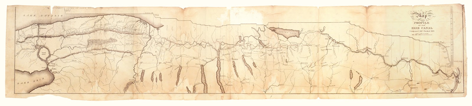
Where The Blue Line Ends... (Part 1)
With the approach of the bicentennial
of the first spadefuls of dirt turned in constructing the Erie Canal, it may be of interest to
explore a bit about the early survey work and the eventual canal construction
in the area that is now part of Schoharie
Crossing State Historic Site. What
was not a given at the time, was the path of the canal from the Schoharie Creek
to Albany. When they broke ground on July
4th 1817 in Rome, the canal “blue line”
ended at the banks of the Schoharie.
Running a canal through the
Mohawk Valley was by no means a new concept.
Going back to the colonial era under the then surveyor general Cadwallader
Colden, it was noted as a potential global improvement and prudent endeavor
for British colonial rule of the continent to at least improve inland
navigation. Travelers for decades
between then and the early 1800’s had noted the geological advantages of the Mohawk Valley – even George
Washington thought it a great concept, though never would have approved of federal monies to pay for a canal.
After a long process of gaining legislative approval for funding, in 1816, Charles
Brodhead had been assigned to survey the route from Rome, NY to the Schoharie Creek. The continuation to Albany would not be
settled until the last possible moments before the construction of that fifty
mile section. Brodhead had a long
surveying past, even ascending an Adirondack high peak in the 1790’s, before establishing
himself in the Utica, NY business world.
Several years pasted before he then heeded the call to Erie work. Brodhead
returned to central NY before the completion of the canal and did not advance
into the history books with those surveyors turned engineers.
As author and historian Gerard
Koeppel notes in his work Bond of Union, that stretch of the
Mohawk Valley that Brodhead was to tasked to survey was already “a region of
merchants, travelers, and crude boatmen, raucous riverside taverns and public
houses, with the comforts and discomforts
of rough progress” (emphasis added). It
also encompassed many of the most difficult elevation changes of the entire
canal route. Brodhead’s character and
experience aligned perfectly for such a task.
Within the company of men
assigned to execute that survey was Canvass
White – noted predominately now in canal lore as not just a surveyor or
engineer but the savior of the project in its earliest stages for his reported
“discovery” of a particular
limestone in NY and the process by which to transform it into hydraulic cement. That cement was necessary to build locks,
culverts and other canal masonry.
With the foolish idea of the
incline plane canal put aside (which would have required an elevated canal
prism 150 feet higher than the Schoharie Creek) the survey would necessitate
the canal to traverse the creek and overcome the elevation changes that occur
across the section and most precipitously toward Albany.
 |
| John Jervis Oneida County Historical Society |
The former ax-man, John Jarvis
was the engineer in charge of the Erie Canal division from Anthony’s Nose to Amsterdam when the 1821 construction
season began. While the section required
four locks, the most daunting task may have involved the crossing through the
Schoharie Creek. Any ease Jarvis
experienced, was gained in this division - according to Koeppel, entirely due to
the previous oversight and contracting of Canvass White. Further oversight of Jarvis by Chief Engineer
Benjamin Wright and
Canal Commissioner Henry Seymour
would provide guidance to build his confidence as the canal inched eastward. And although his section would leak and need
vast repairs in 1822, it was indicative of the nature and conditions of canal
construction through the eastern sections of the Grand Canal – the difficulty
of traversing a region full of “Flood-prone Streams,” need for aqueducts and
the difficult south bank of the Mohawk
River that required the construction of dams, guard locks and culverts.
 |
| Henry Seymour |
The Schoharie Creek was vital in
the hydraulic system of the Erie Canal
even in 1822. It was the primary source
of water to the fifty mile stretch from its banks to Albany; A section that
would require large amounts of flow to conduct passage through the nearly two
dozen locks to reach the Hudson River. In
order to facilitate this transference of creek water into the canal – as well
as ease the crossing of its flowing body – a slack
water dam would be constructed and continually maintained in the Schoharie
even up into the era of the early 20th century when the canalized
Mohawk River no longer made use of the creek’s waters in that fashion.
You can discover more on that topic by reading these previous articles:


Comments
Post a Comment